
Benifallet
BENIFALLET
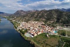
The municipality of Benifallet, with an area of 62.42 km2, is located in the northern end of the Baix Ebre region, on the border with the counties of Terra Alta and Ribera d'Ebre (in the partition with Miravet is the Roca Folletera, historical partition of the municipality of Tortosa). The term confronts with Prat de Comte (W) and Pinell de Brai (NW), municipalities of the Terra Alta; with Miravet (N) and Rasquera (NE), from the Ribera d'Ebre, and with Tivenys (S), Paüls (W) and Xerta (SW), from the same region of Baix Ebre. Very rugged, the municipality extends on both banks of the Ebro, and includes the river valley, bounded on the SE by the elevations of the Cardó Mountains, diving water between the Ebro and the sea, while on the right, the river valley is enclosed and closed by the Aligars and Vallplana mountains and the peaks of Portell.
The Cardó block, to the SE of the municipality, includes the steep Cardó valley, formed under the highest points of the ridge (La Creu de Santos, 941m), landmarks with the neighboring municipalities. The Cardó valley, quite narrow and drained by the Cardó ravine, extends through the Costumà valley and drains into the Ebro to the north of the town of Benifallet. The old convent and spa of Cardó massif, the Punta de l'Agulla and to the west, the Set Serres and the Coll of Tossal de Som stand out; towards the east, the portholes of Xàquera and Cops, or Portell de Cardó, through which pass several old paths that cross the massif. These are extensions of the aforementioned massif, the Caramull hill (421 m), La Tossa (483 m), La Mola and Los Puntals. Of karst relief, there are several fountains and caves, with stalactites and stalagmites (the cave of the Wonders and the Marigot Cave) and some with vestiges of ancient settlement (That of the Aumediella and others).
The Cardó ravine, which forms and has its entire course within the municipality, is not the only stream that runs through the territory of Benifallet. Further south, and also on this left side of the Ebro, there is the Jordi ravine, which also forms in Cardó and drains into the Ebro downstream of the Puig de Raells. On the right, the Ebro receives the Llixem ravine and, between the Vallplana and Aligars mountain ranges, with the Mollets hills and the Mollet tower, the Canaletes rives flows into the Ebro; downstream, on the border with Xerta, the Xalamera ravine flows into it. Mention should also be made of the influence that Xerta's diversion dam (a cultural asset of national interest) has on the water flow of the Ebro, located in this area, near the border with Benifallet. The mountains of the term are generally quite eroded and deprived of their original vegetation due to the ancient and intensive abancal to which they were subjected. Abandoned these margins from phylloxera, today a predominant shrubby vegetation (bushes, shrubs, rosemary, etc.). The forests are predominantly white pine. Cardó is the valley where there is a higher density of forest and where it is less modified (1,544 ha of Benifallet are included in the PEIN of the Serres de Cardó).
HISTORY
The name of Benifallet first appears in documents from 1153. The place already existed before the conquest of Tortosa by Ramon Berenguer IV. In 1208 King Peter the Catholic gave the castle to William IV of Cervera who, in 1215, in turn gave it to the knights of the Order of the Temple. Later, Benifallet returned to the royal jurisdiction through its link with the city of Tortosa. In 1207 Ramon de Montcada gave these places to Bernat Oliver Fuster with his terms and belongings, so that he could own them, exploit them and establish cultivators there.
The first road that connected Benifallet with another town arrived in 1917, therefore, the village before that date communicated with the outside through the llaguts. The llaguts were used to transport people, but also to market products and provide minimum services to the village. The Benifallet boat was used for years to communicate Benifallet with the towns on the other side of the river. The boat stopped working in 1991, the year in which the Llaguter Bridge was inaugurated, an infrastucture that is part of the C-12 or Axis of the Ebro and connects the right bank of the river Ebro with Benifallet. It has a lane for each direction of traffic and a small passage on both sides for pedestrians. The C-43 road reaches Gandesa and allows acces to Pinell de Brai. The T-301 Tortosa-Garcia road leads to the Caves of Wonders. In addition to the town of Benifallet, head of the municipality, the area includes the depopulated areas of Xalamera, Som, Sallent and Costumà, the Cardó spa, the Mollet tower and the hamlet of the Valley.
The floods that covered half of the town with water are considerable, until in 1957 the Mequinensa reservoir was built and the flow of the river was controlled.
AGRICULTURE AND TOURISM
The last decade Benifallet has enjoyed strong tourist growth thanks to the exploitation of the Benifallet Caves and the navigability of the Ebro. At the gastronomic level, the "pastisset de Benifallet" should be highlighted as a local product with recognition throughout Catalonia.
Benifallet, with less than a thousand inhabitants, is an agricultural village which in recent years has made a commitment to agro-industry and tourism. In addition to traditional Mediterranean crops such as almonds, olives and carob trees, a large number of fruit trees are grown there. In irrigated areas, the main ones are peaches and citrus trees with a wide range of varieties in both cases. Peaches are marketed during the months of May, June and July. It is in late autumn and winter that commercial activity focuses on oranges and mandarins, much appreciated in Europe. The fruits of Benifallet, with a temperate climate favored by a relief that makes it more benign, fruit early. In the industrial activity, the most important are fruit handling industries, water-bottling industries, without forgetting those that manufacture pastissets.
In the animal husbandry branch we find poultry farms, rabbit farms, cattle and pigs. The vegetation is formed by the coastal inlet of garric and fan palms; the white pine and the coastal shrub (rosemary, thyme, white rosemary, mediterranean heath ...) spread all over the territory. The riparian vegetation is made up of poplars, elms, tamarisk and reeds, among others. In the mountains of Cardó, we can still find represented the typical coastal holm oak grove with holm oaks, some small-leaved oaks and shrub species such as holly, holm oak, shepherd's cherry or honeysuckle.
The temperate climate, typical of Mediterranean lands, is mild and stable, with little rainfall. It receives the remarkable influence of the relief that makes it more benign.


